• Presentación Smart City y Geolocalización: Héctor García
  • Sample Page
  • ES
  • EN
  • Avda. de Grecia 8. 41012 Sevilla, España
  • |
  • www.geographica.gs

Alberto Asuero

Flight insights with Carto

Want to compare flight routes around the world?

Posted at 11/11/2015 by Alberto Asuero

From ancient Greece, the human being seeks to control the sky. Two prisoners, Icarus and Daedalus, in the Minos Island, built wings with feathers and beeswax to escape his prison.

This myth talks about the desire we all share: to fly, to conquer and use all that great empty space. And we succeeded. We’re up in a thousand ways, we fly and we want to keep flying. It shortens distances, connect us, it allows us to trade, meet, see.

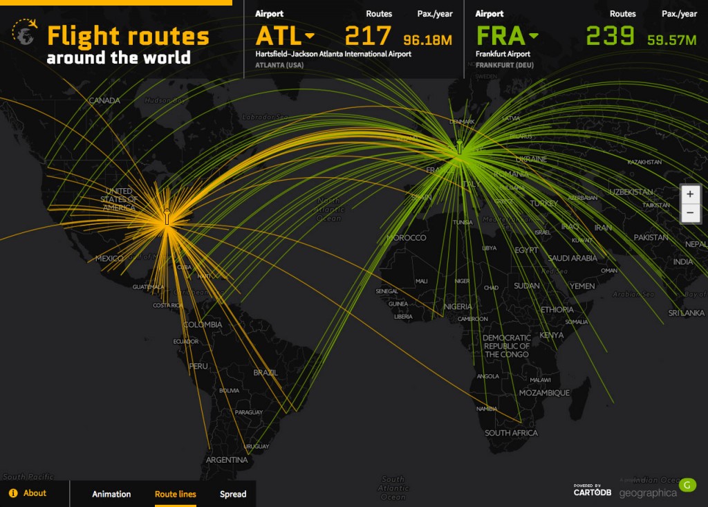
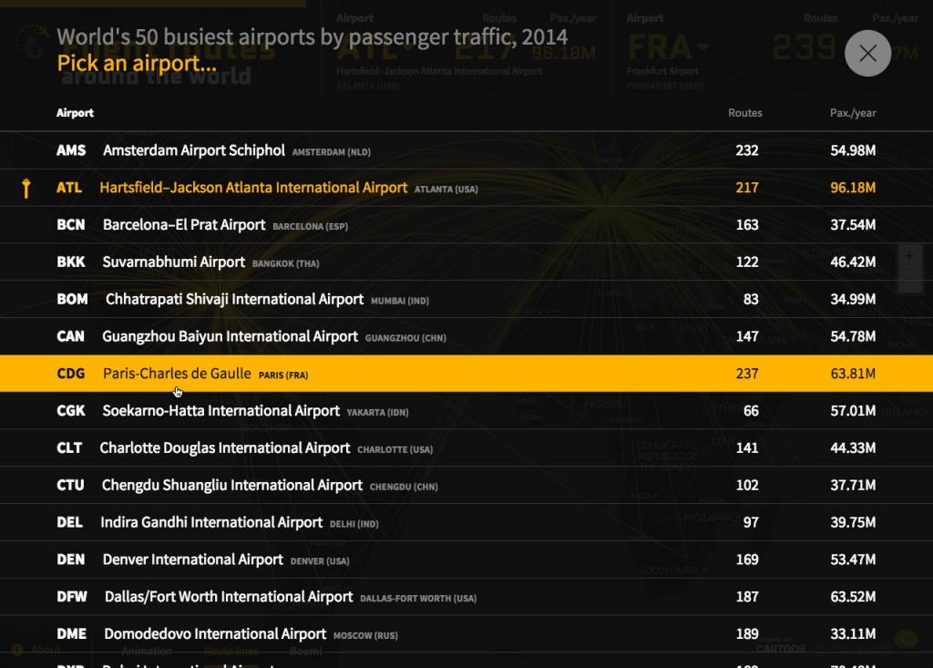
Thanks to the dynamism of Carto’s technology and Geographica’s design. In a simple map we show the 50 busiest airports in the world. We can know the number of passengers passing through them. From the nearly 100 million passengers in Atlanta Airport to 239 daily flights from Frankfurt passing through 86 million passenger in Beijing or 73 million in London. Everything is spectacular.

View online

Routes Hartsfield–Jackson Atlanta International Airport and Frankfurt Airport. Year 2014.


insights

At Geographica we love this kind of works: answering questions after analyzing a bunch of data, so let me share with you the insights extracted from this map.

Geostrategic balances are changing around the world; the most important of them is perhaps the change of equilibrium between the Atlantic and Pacific axis. New conflicts, like the Ucranian one or the war on ISIS are rendering old flight routes unflyable and forcing airlines strategists to change traditional and established routes and hubs for new ones. All this has an impact on the global network of air traffic.

  • New transiberian routes from North Eurasia to the Far East are developing heavily: this explains the incredible rise of Moscow’s Domodedovo International Airport as a new hub.
  • Likewise, new north equatorial routes are being established: the transit from Europe to the Far East takes it route south making the Dubai International Airport the most important hub of the arabic nations.
  • Pacific transit is on the rise: japanese, chinese, and US west coast airports remain among the most active in the world, but also Licenciado Benito Juarez International Airport in Mexico and Sao Paulo’s Guarulhos International Airport increased connections with the Far East honor the Pacific Axis increasing importance as a rising international scenario with respect to the Atlantic one.
  • Europe is lagging behind: in addition to the US, Europe was the heart of the global air traffic network, being France and England powerfull hubs of transport for their former colonial territories. This importance has begun to dematerialize somehow, resulting in a more interconnected network (like in the case of Africa) not necessarily dependant from european or north american hubs. Paris Charles de Gaulle has fallen in importance, while London’s Heathrow and Gatwick still retaining its crown among the most important hubs in the world. However, it is Frankfurt am Main International Airport the one that has become the true european hub. Madrid’s Adolfo Suárez has also seen an uprising thanks to its specialization in routes to Latin America.
  • Africa is still lacking interconnections: although the net grow of internal african flights is sustained, and that the interconnectivity among african hubs has increased (no more so many trips to France to go back to a neighbouring country), Africa is still the continent with the least interconnectivity rate in the world.
World's 50 busiest airports by passenger traffic, 2014
World’s 50 busiest airports by passenger traffic, 2014
Simple quiz as an introduction to the project

You can check it out at http://flightroutes.geographica.gs

CartoDBGeoDataScienceOpen Data
GEO_blog_alberto
Posted at 11/11/2015 by
 Alberto Asuero
Chief Technology Officer
SHARE
Posted in: CartoDB, GeoDataScience, Open Data | Tagged: Datascience, DataViz, flight routes, geographica

Making tiles with Mapnik

Towards a tiles engine based on Spark

Posted at 10/05/2015 by Alberto Asuero

Why do we make tiles? For a reason of efficiency and speed. To create tiles consists of making a pyramid of the world and rendering the images previously. In this way our maps are faster because they only download the images that had been rendered.

The WMS services were good several years ago but today the needs are a quite different, and there are much better solutions for applications dealing with a large quantity of users. It has it’s uses, but it’s not a solution for scalable applications.

I’d like to tell you our experience:

We tile the orthophoto of Andalusia with an high level of detail (level 18). For that we used gdal2tiles.py. The first issue to deal with was the format, for the year 1956 it was a MrSID and we had to fight a bit with GDAL. The second one, and much harder, was to create the mosaic.

tiles: El rompido, year 1956 on the left and the year 1979 on the right
El rompido, year 1956 on the left and the year 1979 on the right

Check this out at CartoDB. Seville year 1956 – Seville year 1979

Even thought we achieved it, it looked really well but it took too much time (50 days). It was unacceptable so we start working to improve the timing and furthermore to have something that allow us to take data from the most common data sources.

The target was to tile the maps of each of our applications without thinking about the format of the data. We create Equidna – 100% OpenSource -, with this tools we’ve created hundreds of maps for different clients and we’ve been able to reduce the timing thanks to a multiprocessing implementation. It was a large improvement, using gdal2tiles it took 50 days and with Equidna we reduced it to 30 days.

Equidna is based on Mapnik and it allows you to make tiles with a wide variety of data sources: PostGIS, Shapefiles, GeoJSONs, GDAL, raster, etc…

Right now, we’re working on an improvement based on BigData using a Map/Reduce algorithm (despite of I’m not a fan the term “BigData” I think it helps for a better understanding). With this new approach we assign each machine a region of the world.

So, using an elastic platform as Amazon EC2 we can launch N machines; if a process takes 50 days, if we launch 50 machines it will take 1 day (aprox.) and the cost will be the same. We’re developing this platform on Spark.

In a few months we’ll post the results, and of course, it will be OpenSource.

BigDataGIS
GEO_blog_alberto
Posted at 10/05/2015 by
 Alberto Asuero
Chief Technology Officer
SHARE
Posted in: BigData, GIS | Tagged: Equidna, geographica, Mapnik, Spark, Tiles

© 2022 Geographica. Todos los derechos reservados.

  • English
  • Español