• Presentación Smart City y Geolocalización: Héctor García
  • Sample Page
  • ES
  • EN
  • Avda. de Grecia 8. 41012 Sevilla, España
  • |
  • www.geographica.gs

GIS

Big Data & IoT, the best ally for Geolocation Apps

How to bring your Geolocation Apps to the next level with Big Data

Posted at 29/11/2016 by azahara

Aplicaciones de Geolocalización

Geolocation applications and those that, without being specific, include the spatial dimension, are becoming more numerous. Not in vain, even though they are heterogeneous, many of the data generated by Big Data and the Internet of Things –IoT– are characterized by the fact that they have a geographical component. 

[Read more…]

BigDataGISIoTSmart City
Posted at 29/11/2016 by
 azahara
SHARE
Posted in: BigData, GIS, IoT, Smart City | Tagged: Big Data, geolocalización, IoT, Smart City

Geomarketing to make strategical decisions

Geomarketing, your best ally to make strategical decisions

Posted at 24/10/2016 by azahara

Geomarketing to make strategical decisions

Geomarketing is a concept that is gaining importance within the business environment. Even though  its essence is nothing new, due to the advances in GIS technology and the ones in displaying massive amounts of data -BIG Data or Data Science-, it has become a revolutionary tool for making strategic decisions. Let´s get started.

[Read more…]

DatascienceGeoDataScienceGISGISUncategorized
Posted at 24/10/2016 by
 azahara
SHARE
Posted in: Datascience, GeoDataScience, GIS, GIS, Uncategorized | Tagged: Geomarketing, Geomarketing to make strategical decisions, gis, Sales

Time, the best master.

Geographica have a new web

Posted at 04/05/2015 by Héctor García

We evolve, hope you like it.

geographica-dia2-0275-Editar

1.- First period; 2007 – 2008

What were we doing? SVG and Flash viewers. Desktop was dominated by ArcGIS and SmallWorld. Clients still asked for paper maps.

Logo Geographica

Our first logo.

Clients = Local companies and administrations

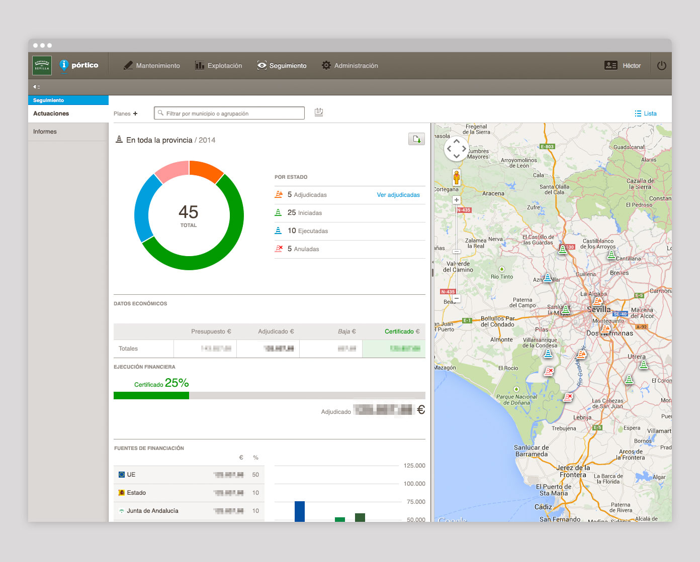
2.- Second period; 2008 – 2012. Open Source and Design explode within Geographica. We chose PostGIS, QGIS, MapServer, R and GDAL. We made Java and HTML5 viewers, we used GM, OSM and OGC. We developed and released our first apps for iOS and Android. We succesfully finished our first geographic management dashboards.

Clients = Administrations, European Projects, National private companies and Scientific institutions.

GW_galeria_portico_05

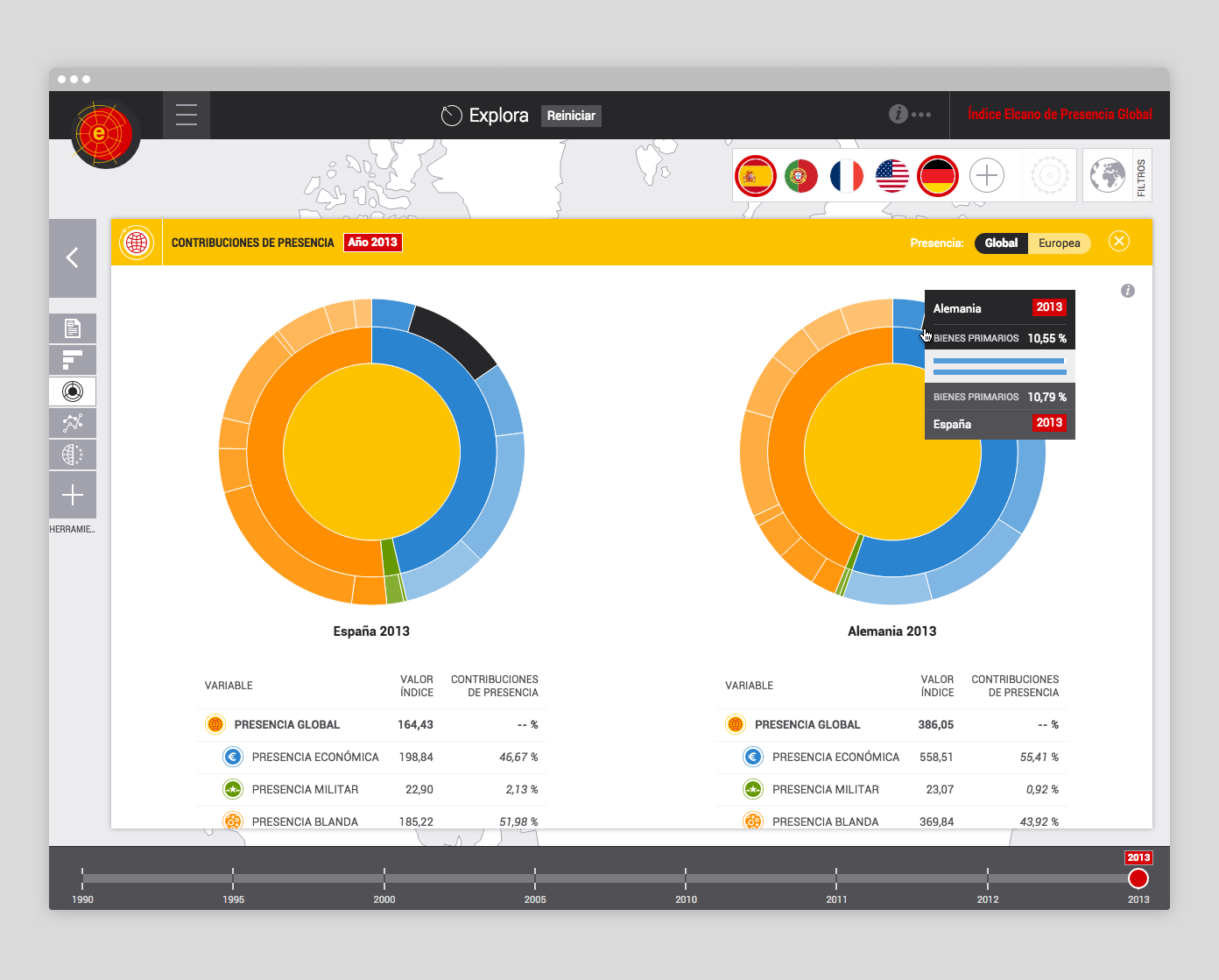
3.- 2012 – 201?. Growth stage. Data (at last!) start winning the battle. We do GIS and Data Science. We use Hadoop, Spark, Node.js, Python, SciPy, Maply, CartoDB, Mapbox, Docker, gscope. A new, fascinating and funny era.

GW_galeria_elcano_05.jpg

Clients = National and international private companies, national and international institutions, university and scientific organizations.

Where are we going? To create more things, with more people, in more countries. We really want to keep working, creating jobs from here for the whole world. We would make it if we continue taking care of the most important thing; our team, which has been, is and will be the key of Geographica.

Geographica: we are growing and evolving

DatascienceGIS
GEO_blog_hector
Posted at 04/05/2015 by
 Héctor García
Chief Executive Officer
SHARE
Posted in: Datascience, GIS | Tagged: geographica, strategy, web

© 2022 Geographica. Todos los derechos reservados.

  • English
  • Español